|
|
|
|
|
|
 |
 |
|
|
 |
 |
|
|
 |
 |
|
|
 |
 |
|
|
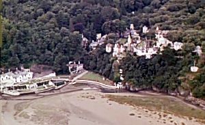
PORTMEIRION
HISTORY
[This page and 3 linked ones have
been transferred from the original website which began in 2002 and is no longer
maintained.]
History sub page 1
History sub page 2
History sub page 3
Home
PORTMEIRION 100 YEAR JOURNEY BOOK
|
|
|
|
|
|
|
|
|
|
|
|
|
|
|
|
|
|
|
|
|
|
Mediaeval Deudraeth Castle and Aber Iâ Estate - a summary from reported accounts. |
|
pre- 1700 |
See text above and on History Main and History 1 pages. |
1700 |
The castle of Aber Iau (another alternative spelling) is mentioned by Edward Lhuyd. |
1795 |
A map by John Evans map shows only two farm buildings (contrasting with Clough Williams-Ellis' description as having been a little hamlet lying in a cove by a waterfall with shipyard, foundry and watermill, plus a cluster of cottages). |
1804 |
An attempt was made to clear up the mystery as to whether any remains of Deudraeth Castle existed but without success. |
1816 |
The course of the River Dwyryd moved from south of the small estuary island "Ynys Gifftan", bringing the channel closer to Aber Iâ. |
1819 |
OS drawing shows "Castell Deudraeth" and a shaded area and also a place name at the site where Bron Eryri (the present Castell Deudraeth) was later developed. The 1821 map repeats the 1819 content. |
1828 |
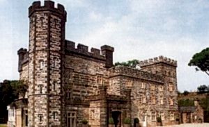
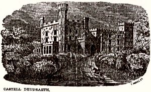
Captain Barton built on the foreshore at Aber Iâ a quay where he intended slates would be transferred from River Dwyryd boats to ships. He had built the Bron Eryri villa (later bought by David Williams in 1841 and remodelled and renamed Castell Deudraeth). |
1829 |
The quay was enlarged and in 1834 larger ships were able to visit. There are rope marks on foreshore rocks confirming the quay’s extent for slate loading. |
1834 |
The vessel '"Progress" was launched from Aber Iâ, being a larger ship able to carry over 60 tons. The would-be trade did not last long because of the poor approach from the sea and the rival Porthmadog port. |
1835 |
Not until the 19th century was there any evidence of designed landscaping. There is evidence of slight industrial activity, with relics of shipping, mining and a foundry. David Williams purchased a part of the peninsula and would continue to expand and consolidate his estate over the next 22 years. |
1836 |
An Admiralty chart shows a foundry at Aber Iâ and nearby a ventilation shaft to a mining chamber below. A century or so later Clough Williams Ellis fashioned a dovecote structure around this, converting the chimney over the defunct mining chamber's ventilation shaft. |
1838 |
The OS map shows a road or track extending south west and a lodge being marked near the Minffordd junction, plus the main drive going past (forking with one arm going to Aber Iâ and the other going further inland around a knoll to the southern tip of the promontory). The foundry was no longer shown and must have ceased to function. |
1840s |
The Aber Iâ estate began to receive some grooming, with lawns, terraces, fountains, rockeries, grottoes, paths and drives being provided as an appropriate setting for the elegant new stuccoed mansion built there. Reputedly fortunes were spent on plantings and embellishments. |
1851 |
The Bron Eryri residence was converted into a castellated mansion and was renamed Castell Deudraeth by 1858. |
1861 |
Aber Iâ was sold (leasehold) with a sale catalogue describing an extensive garden. A journalist described crossing the wooded area (the Gwyllt) and finding a walled garden beyond which was a house. On view were a number of foreign waterfowl on a tiny pond and two monkeys, the garden walls being netted and bearing fruit trees. A raised terrace in front of the villa (or mansion) had shrubs, statuettes and other ornamental appendages. To the northern end of the terrace was a miniature raised pleasure ground, bounded by rocks and abounding in cascades, water jets, romantic footpaths and a variety of foreign shrubs and flowers. |
1861 |
David Williams was appointed High Sheriff of Merioneth |
1867 |
(As later recalled by an octogenarian resident of Minffordd in 1927): The old Castell tower was about 10 feet tall with a platform on the top from which the castles of Harlech and Criccieth could be seen, there being no trees then to obscure the view. The ruinated tower was semi-circular, 10-12 feet in diameter. See other pages within this site for more comment. |
1869 |
The ancient Deudraeth castle was finally razed by Sir William Fothergill-Cook (inventor of the electric telegraph) to prevent the ruins becoming known and attracting visitors. The stones were later used to build the Portmeirion campanile in 1925. (But see comment on other pages). |
1889 |
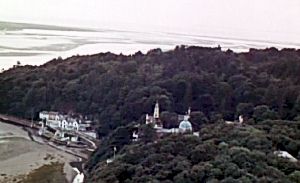
An admiralty chart shows ‘boat house (foundry)’ indicating that the boat house had overlain the site of the foundry. Also noted around this time newly planted woodland "Coed Aber Iâ" surrounding the main house with a network of paths plus views from some cliffs. An enclosed south facing area of shrubs existed north and east of the house, plus a large walled garden and gardener's cottage lay in the sheltered valley, with a large pool fed by a stream (the present day fishpond and Mermaid cottage). |
1914 |
An inventory for the county of Merioneth by the Royal Commission on Ancient Monuments in Wales described the site of a castle at Aber yau (as it was also called). It mentioned a hillock in the grounds of the residence where there was a small structure which might have been exaggerated into a "castle". The surviving remains rendered it by no means certain. The site was a roughly circular plateau of rock, the centre of which had been hollowed out into a kind of pit. The diameter of the plateau was 60 feet and the pit was 8 feet deep. There was mention of remains of a wall and that a considerable quantity of stone had already been removed from the place to erect a modern house. (More comment on this appears on later pages). |
1914 to 1918 |
Mrs. Haigh (Adelaide Emma Jane Haigh), who had been tenant at Aber Iâ, died during the First World War. She lived reclusively at Aber Iâ, preferring the company of dogs for whom she created the Dogs’ Cemetery. Subsequent tenants took a lease during the next decade or so. During this time George Henry Caton Haigh (who retained the lease until his death in 1940) continued to develop earlier work and as a breeder of rhododendrons began introducing some unusual varieties (he being an authority on Himalayan flowering trees and exotic plants). |
1925 |
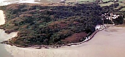
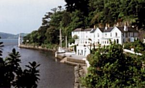
Clough Williams-Ellis bought Aber Iâ from his uncle, Sir Osmond Williams. He was inspired by the Mediterranean-like setting, not dissimilar to Portofino, in Italy, a particular favourite place of his. His Portmeirion hotel was opened in 1926 and the name Aber Iâ was dropped. The Mermaid and White Horses cottages were improved and a main programme of building commenced until the Second World War, continuing in the mid fifties until 1970. (The remains of the semi-derelict harbour structure Fort Henry of around 1928 still exists, it being once designed by Clough for sunbathing, bathing, boating and barbecues.) |
1931 |
A prep school was evacuated to Castell Deudraeth for a while. The building was restored by 1939, the park, lawns and terraced flower gardens being brought back to their previous century perfection. The building received central heating and mains water plus electricity and bathrooms. "In some respects it actually surpasses Portmeirion itself as a place to stay", it was once said. |
1939 |
Portmeirion's "famous gardens" were described and credit was given to Caton Haigh whose "adjoining gardens can be freely enjoyed by all visitors to Portmeirion". |
1954 - 1970 |
Daughter of Sir Clough Williams-Ellis, Susan Williams-Ellis and her husband Euan Cooper-Willis took an increasing role in maintaining the hotel and improving the cottages and village as Clough became more senior. Today their son Robin Llywelyn is managing director of Portmeirion. |
1981 |
Main Portmeirion hotel building destroyed by fire. |
1988 |
Main Portmeirion hotel building reopened, after renovation and reconstruction. |
|
|